Showing posts with label Alpinism. Show all posts
Showing posts with label Alpinism. Show all posts
Monday, February 26, 2018
VIDEO: Reinhold Messner speaks about a balance of tourism in Georgia - or is this video a PR Campaign for mass tourism ?
Rheinhold Messner's trip to Georgia Follow the legendary explorer
Rheinhold Messner on his way through epic Georgian mountains! Majestic Ushba Mount, breathtaking landscapes of Greater Caucasus, fruitful vineyards and ancient churches in the lowlands are ready to be discovered!
Source: https://georgia.travel


Tuesday, March 08, 2016
NEUERSCHEINUNG: Mario Casella; Schwarz Weiss Schwarz. Eine abenteuerliche Reise durch das Gebirge und die Geschichte des Kaukasus (as-verlag.ch)
(as-verlag.ch) ITAS-Preisträger Mario Casella erzählt von seiner abenteuerlichen Reise durch das Gebirge und von den Menschen und der Geschichte des Kaukasus in "Schwarz Weiss Schwarz" / Ab April im AS Verlag
 Sie reicht von den "dunklen Tiefen" des Schwarzen Meeres bis nach Baku an der Küste des Kaspischen Meeres und misst 1.000 Kilometer: die kaukasische Bergkette. Der Höhenrücken trennt Europa von Asien, hier leben unterschiedlichste ethnische Gruppen, werden mehr als vierzig (!) Sprachen gesprochen und die Region war und ist umkämpft. Der Alpinist und Journalist Mario Casella hat die Bergkette zusammen mit dem russischen Alpinisten Alexey Shustrov auf Skiern durchquert und erzählt von diesem Abenteuer in dem mit dem ITAS-Preis für das beste Berg- und Abenteuerbuch ausgezeichneten Titel "Schwarz Weiss Schwarz". Das (Tage)Buch mit Reportagen umfasst 280 Seiten und erscheint im April im AS Verlag – 40 Abbildungen begleiten die Texte.
Mario Casellas Ziel und Antrieb: Den authentischen Kaukasus und dessen Bewohner kennenzulernen und zu porträtieren. So erzählt er in seinen Reportagen sowohl von der wechselvollen Geschichte des Landes als auch den Menschen und der Landschaft. Und natürlich berichtet er von der Skidurchquerung der Kaukasuskette von Derbent am Ufer des Kaspischen Meeres bis hin nach Sotschi.
Mario Casella
Schwarz Weiss Schwarz
Eine abenteuerliche Reise durch das Gebirge und die Geschichte des Kaukasus
2016
Hardcover, ca. 280 Seiten, ca. 40 Abbildungen
AS Verlag
ISBN 978-3-906055-44-2
€ 26,90 | CHF 29,80 * (* empf. VK-Preis)
Erscheint im April 2016.

Mario Casellas Ziel und Antrieb: Den authentischen Kaukasus und dessen Bewohner kennenzulernen und zu porträtieren. So erzählt er in seinen Reportagen sowohl von der wechselvollen Geschichte des Landes als auch den Menschen und der Landschaft. Und natürlich berichtet er von der Skidurchquerung der Kaukasuskette von Derbent am Ufer des Kaspischen Meeres bis hin nach Sotschi.
Mario Casella
Schwarz Weiss Schwarz
Eine abenteuerliche Reise durch das Gebirge und die Geschichte des Kaukasus
2016
Hardcover, ca. 280 Seiten, ca. 40 Abbildungen
AS Verlag
ISBN 978-3-906055-44-2
€ 26,90 | CHF 29,80 * (* empf. VK-Preis)
Erscheint im April 2016.
Tuesday, September 03, 2013
ALPINISMUS: Christian Stangl hat "Triple Seven Summits" bezwungen - In Georgien: Shkhara (kleinezeitung.at)
 |
| Christian Stangl am Shkhara Foto © APA | ARCHIL BADRIASHVILI |
(kleinezeitung.at) Der Alpinist und Extremsportler Christian Stangl hat sein Ziel erreicht, als erster Mensch auf den jeweils drei höchsten Bergen der sieben Kontinente zu stehen. Der Absteig vom Shkhara führte jedoch fast zu einem Desaster.
Vergangenen Freitag bezwang der 47-Jährige mit seinem Bergführerkollegen Archil Badriashvili aus Georgien und Bergsteigerkollegen und Kameramann Michael Haidn aus Österreich als Schlusspunkt den Shkhara (5.193 Meter) an der russisch-georgischen Grenze, teilte seine Sprecherin heute, Dienstag, der APA mit.
Das Austro-Georgische Dreierteam ist damit heuer das bisher einzige Team, das den Shkhara von Georgien aus erfolgreich besteigen konnte. Dennoch führte der Abstieg beinahe in ein Desaster: Trotz guter Wetterprognose gerieten die Alpinisten nämlich in einen Sturm, der sie auf 4.200 Metern festhielt. In der ersten Nacht schneite es bereits 60 Zentimeter, wegen des steilen Abstieges und der damit verbundenen Lawinengefahr war ein weiterer Abstieg nicht möglich. Nach drei Tagen des Wartens - Lebensmittel und Brennstoff waren bereits zu Ende - forderte Stangl via Satellitentelefon Hilfe aus der Luft an.
Der Shkhara gilt sowohl von Süden (Georgien) als auch von Norden (Russland) als schwieriger und sehr gefährlicher Berg. Derzeit befindet sich Stangl in Tiflis und macht sich morgen auf den Weg, um sein Equipment aus dem Basislager zu holen. Sobald die Daten eingeholt sind, werden sie zur Verifizierung weitergeleitet.
Sieben Jahre unterwegs
Sieben Jahre lang war Stangl unterwegs, um als erster Mensch auf den jeweils höchsten, zweithöchsten und dritthöchsten Gipfeln der Kontinente zu stehen – den "Triple Seven Summits". Der Auftakt erfolgte am 25. Mai 2006 am ersten und zugleich höchsten der 21 Berge, dem Mount Everest (8.848 Meter). Einen absoluten Tiefpunkt gab es im Sommer 2010, als der Bergsportler mit einer falschen Gipfelmeldung vom K2 (samt falschem Gipfelfoto und dem mehr als zögerlichen Eingeständnis, nicht oben gewesen zu sein) für Negativschlagzeilen sorgte.
Stangl dürfte mit dem Shkhara gleich drei Rekorde erreicht haben: Er ist nicht nur der erste Mensch, dem die "Triple Seven Summits" gelungen sind, seinen Berechnungen nach ist er auch der Erste auf den sieben zweit- und den sieben dritthöchsten Gipfeln der Erde. Bei der Besteigung der "Second Seven Summits" hatte sich Stangl zuletzt übrigens einen Streit mit dem Südtiroler Hans Kammerlander geliefert, der beim Rennen um die sieben Zweithöchsten allerdings auf einem falschen Gipfel gestanden sein dürfte.
Bei etlichen Bergen war nämlich bis vor kurzem die genaue Höhe umstritten. Zwar waren die klassischen "seven summits“ ganz eindeutig verifiziert, bei den zweit- bzw. dritthöchsten Bergen der Kontinente war dies aber bis vor kurzem nicht der Fall. Um alle Eventualitäten auszuschließen, bestieg Stangl "sicherheitshalber" insgesamt 30 Berge weltweit, um am Ende auch tatsächlich auf den richtigen 21 Gipfeln gestanden zu sein. Außerdem dokumentierte der Steirer seit seinem K2-Debakel jeden Bergerfolg ausführlich mit Gipfelfoto, Gipfelvideo und einem von der Universität Graz zur Verfügung gestellten Differenzial-GPS-Gerät, das besonders exakte Höhen-Messungen zulässt.
Inzwischen steht für Stangl der wissenschaftlichen Anspruch des Projekts sogar über dem sportlichen. Die "Triple Seven Summits" seien eine Rückkehr zum "Ur“-Alpinismus vergangener Epochen, als Forscher und Bergsteiger auszogen, um zu erforschen, zu vermessen und zu erkunden. Mit diesem Projekt hat der Österreicher die umfangreichste Alternative zu den bekannten alpinen Zielen der "seven summits“ (erstmals bestiegen von Dick Bass 1985 – USA) oder auch den "Vierzehn Achttausendern“ (erstmals bestiegen von Reinhold Messner 1986 – Italien) geschaffen.
Friday, August 31, 2012
SVANETI: The Caucasus: Georgia on the Crossroads. Cultural Exchanges Across Europe and Beyond. By Silvio Calvi (fondazione-delbianco.org)
(fondazione-delbianco.org) The discovery of the Caucasus mountains as playground for mountaineers came immediately after the great climbs in the Alps.
After climbing the Matterhorn, with a first ascent that was also a tragedy, British climbers turned their eyes into a new area: the Caucasus.
The pioneer was Douglas Freshfield, who spent 13 summers in the Alps and the decided to change his horizons.
In 1868 he spent his summer in Caucasus and went back to London after climbing the two highest extinct vulcanoes in the area, Kasbek and Elbrus.
Easy climbs, from a mountaineering point of view, but what he described was enough to lead his countrymen to a new type of race, whose goal was simply to be the first in the ascent of unclimbed and untrodden peaks. Information was not easy available and the maps and sketches on which mountaineers prepared their expeditions were quite simple. The expedition in itself was a discovery: from one valley to the other even the language was different, as everyone knows also today.
But they succeeded, crossing the Caucasus from East to West.
The appearance of Freshfield’s first book Travels in the Central Caucasus and Bashan; including Visits to Ararat and Tabreez and Ascents of Kazbek and Elbruz was a turning point and the following decades were the years of discovery, much as the events in the Alps after the first climb of Mont Blanc.
Mountaineers returned with beautiful pictures and maps were prepared to show the details of the area.
Among the photographers, outstanding were the images of Mr. de Dechy and, most of all, Vittorio Sella, who travelled by himself and with Freshfield, with a keen eye not only for nountains, but also for landscape and people. His images of Svaneti are an outstanding example of how you can travel trough a country documenting the existing life.
The tragedy that took place in 1888, with four British climbers disappearing north of Shkara slowed the race for discovery: as always death of climbers brings to a serious thought about the essence of climbing and risk.
After the British, the Germans: they completed the discovery of Caucasus and they even installed, for an easier exploration, the “German Bivouac” on the North side of Ushba, staying there for weeks and climbing the surrounding summits.
We should not forget that climbs were performed thanks to the help of Swiss or Italian mountain guides, used to altitudes and professional of the summits.
The locals stepped in later: the most famous was Mikhail Khergiani, son of a Georgian national hero who climbed Elbrus only to take off the signs of the German ascent during the occupation of Russia during World War II. Misha, as he was called, climbed not only in Caucasus, where he opened new routes on the family mountains, but also in Britain, Mont Blanc and on the Dolomites, where he was accustomed to go to defy the most difficult routes. On one of these, the Livanos in the Su Alto of the Civetta ranged, he died of a sad accident in 1968 and local mountaineers still remember his person.
At those times it was not easy to travel to and from Russia and the Caucasus mountains disappeared from the sight, obscured also by the race to the 8.000 himalayan peaks.
Nonetheless Russian mountaineers kept the flame up and continued climbing, staying in touch with the outside world in spite of lack of resources and initiatives, climbing also in Himalaya thanks mostly to personal initiatives after 1989 and the disappearance of the USSR.
Today Georgian climbers and organizations are working toward the rediscovery of the Caucasus, putting up all efforts to make the area visited by foreigners as well as locals.
One area in undisputably the jewel of Caucasus: the Svaneti area.
An isolated valley, difficult to reach because of bad roads and time-requiring transfers from the capital, Tbilisi, populated by Svans, proud of their customs, language and heritage.
It includes villages which are a UNESCO heritage for the architectural and environment landscape.
What is necessary for the development of a local mountaineering culture?
First of all it is necessary to preserve the environment and the local economy, through the development of sustainable practices.
Then the mountains must be brought to the attention of the outside world: Mount Ushba is known as the “terrible”, as the Matterhorn of Caucasus. It requires great ability to climb it and only the best can do it.
Aside from the prospective off climbing, as it happened in the Alps, a network of huts and trails has to be established.
This is happening already, thanks to the initiative of the local Svaneti Tourism Center and the Georgian Union of Mountaineering Associations, which has marked the best trails in the area, and to the help of other mountaineering clubs like the Italian Alpine Club. A map including all of the trails is under preparation and with the distribution of the map, articles in mountaineering magazines, information on media, the attendance of climbers and trekkers can be expected.
A network of huts can be established allowing people to stay comfortably up in the mountains to enjoy the views and, why not, go on summits by the easy routes.
Let alone the fact that the difficult ones are still there to be explored.
Projects are going one to prepare a guidebook of Georgian mountains like the ones we are used to in Europe.
Obviously it is necessary to overcome the difficulties due to the political situation and the relations with Russia: travels like those made by Freshfield and company seem impossible today.
But as mountaineers know well, mountains do not belong to politicians and there will be certainly a time in the future when the travel routes of Freshfield or Sella will be repeated again, zigzagging through borders in peace.
Promoted by:
Romualdo Del Bianco Foundation
Palazzo Coppini Via del Giglio, 10
50123 – Florence (Italy)
ALPINISM: Mikheil (Misha) Khergiani (1932-1969), a Georgian alpinist. (svanetitrekking.ge)
(svanetitrekking.ge) The major indiginous inhabitants of Svaneti region are Svans, they speak their own original non-written language (dialect) - Svanuri that belongs to the group of Georgian languages (dialects). Svaneti is one of the charming pieces of the multy-ethnic and cultural mozaic of Georgia.
Svans, as well as all Georgian highlanders are well acustomed to the mountain life-style. The increased risk factor, frequent avalanches, mudflows and torrents, landslides, rapidly changing climate conditions, severe winters and etc. require great endurance, shrewdness and skills from the local population. The skills and tools used by highlanders in their daily work are primitive but surprisingly rational. It's an impressive picture watching highlanders sliding huge logs or haystacks down through the curved steep slopes or accompanying a hunter up in the mountains. No wonder that Svaneti raised many high class mountaineers and alpine guides. The best proof for the abovementioned is Mikheil Khergiani!
Mikheil (Misha) Khergiani (1932-1969), a Georgian alpinist, Honoured Master of Sports of the Soviet Union (1963), USSR Master of Sports of International Class (1967), thrice USSR Champion in Alpinism and seven times USSR Champion in wall climbing, a perfect master of mountain and rock climbing. He was the most popular sportsman in the former Soviet Union and beyond its borders. Since 1976 the Khergiani memorial tournament in wall climbing has been established. In 1969 one of the nameless peaks in Turkestan Range was named after Mikheil Khergiani. In 1971 a special Khergiani prise for USSR wall climbing tournament was introduced. In 1978 a small planet N3234 discovered in the solar system was named in Mikheil Khergiani's honour.
Mikheil Khergiani's home-museum is opened in the town of Mestia, where the whole picture of his life is displayed.
Georgian highlanders have been using the Caucasus passes for traveling and transportation since ancient times. They communicated with domestic and neigbouring regions. The most remarkable example of massive movement through the Caucasus passes is the emmigration of the Georgian King Vakhtang VI and his suite, consisting of approximately 1200 nobles, to Russia (in 1724). Their route led from Notsaruli gorge through Gurdzi-Vtseki mountain pass (3400) and Pastagi glacier to the Digoria. The mentioned route still belongs to the most difficult itineraries of mountaineering tours.
It is also noteworthy, that 4100 meters above sea level on the slopes of Mkinvartsveri there is the cave of Bethlehem - the oldest monument of Christianity, the hermits abode.
Georgian folk legends and tales tell about the people who climbed up the mountains in ancient times. According to the legends in XVII century a priest Yoseb Mokheve had even climbed up Mkinvartsveri (5033 meters).
Wednesday, August 15, 2012
CLIMBING: 2011: Ushba (4,710m), south pillar, Harakternik. By Lindsay Griffin, Mountain INFO (aaj.americanalpineclub.org)
(aaj.americanalpineclub.org) By Lindsay Griffin, Mountain INFO, from information supplied by Anna Piunova, mountain.ru
Ushba (4,710m), south pillar, Harakternik.
 |
| Ushba from south. Northwest summit (4,694m, left) and Southeast (Main) summit (4,710m). Normal route to Northwest summit (Almer-Cockin, 1888, 4A) reaches gap between summits from far side. (1) Artsishevsiy, 1971, 5B. (2) Grigorenko-Prigoda, 1972, 5B. (3) Myshliaev, 1962, 5B. (4) Voloshanovskiy, 2010. (5) Monogarov, 1960, 5B. (6) Harakternik, 2011, 6A. (7) Kensitskiy, 1972, 5B. (8) Kustovskiy, 1962, 6B. Supplied by Anna Piunova |
The south face is ca 1,500m high. In early July the three Ukrainians first climbed 900m up easy rock (2-3) and glacial terrain, followed by 300m on the crest of the ridge to where things became difficult. About nine pitches (max 5b) led to the base of the pillar. The next three pitches gave largely free climbing, up to 6c, with short sections of A2 and A3 (skyhooks and Iron Hawks/birdbeaks). About four more pitches, up to 6c and A3, took them to an overhanging section. To this point they had followed the line climbed in 2010. The next 130m provided the crux, beginning with a 25m overhanging wall (A3). More 6b and aid took them to the top of the pillar.
On the upper section most ascents follow the right side of the final buttress, the Red Corner. These Ukrainians climbed the center in four fine pitches of 6a. They bivouacked on the final ridge and reached the summit at 8 a.m. on July 7. Starting down by the classic 1903 Heibling-Schulz Route (5A) on the southeast and east flanks, they found the snow too dangerous and bivouacked again, continuing their descent early next morning. Total time spent on the mountain was five days, and the route was named Harakternik (6A, 6c and A3). They had been lucky with the weather, which was still a bit wintry, being hampered only by a strong wind.
CLIMBING: 2010: Chaukhi Mountains, by S. Richardson (aaj.americanalpineclub.org)
(aaj.americanalpineclub.org) Chaukhi Mountains, Javakishvili, Perseverance.
By Simon Richardson, Alpine Club
 |
| Asatiani south face showing the Normal Route. |
During April, while Graham Dudley was making a ski ascent of Kazbek (Kasbegi, or more properly Mkinvartsveri, 5,034m) in the Eastern Caucasus, he noticed an attractive range of lightly glaciated peaks c30km to the southeast, and was determined to come back for a ‘look’. I joined him for a seven-day visit in September.
Research revealed these were the Chaukhi mountains, close to the Russian border and known as the Dolomites of Georgia, boasting fine alpine rock routes. The massif consists of a ridge of unusual, metamorphic, volcanic rock, with four separate summits, the highest, Asatiani, 3,820m. It is surrounded by grassy hills rising to 3,500m, although to the southwest a steep peak holds a big wall that typically takes three days to aid climb and is rarely ascended. The area is attractive and can be reached in a three-hour 4WD from Tbilisi (local bus or normal taxi is much cheaper but slower), and a two-hour walk with horses (cheap and easy to arrange). We established base camp at 42°33.256′ N, 44°46.321′ E.
 |
| The north face of the Chaukhi Group. (A) Asatiani (B) Kameruni, (C) Leonidze, and (D) Javakhishvili. (1) Russian 6A, (2) 4B, (3), 5A. (4) 4A, (5) 5B, (6) 4A, (7) 5A, (8) 5A, and (9) 5B. Simon Richardson |
Our stay caused a little local excitement. Apparently we were the first foreigner visitors to climb technical routes. The area is popular with trekkers; we saw a couple of parties each day and invariably they proved to be from Israel. Non local climbing parties, for example from Estonia, have either hill walked or made simple Grade I scrambles. However, we were certainly not the first overseas party as it is possible that Asatiani was first climbed by the Scottish female, Una Cameron (Una Cameron's Climbs and Expeditions), in 1932. Russians must certainly have climbed here, and there was mention of a Czechoslovak team in the 1980s.
Since we knew nothing of the area, we spent our first day climbing the Normal Route on Javakishvili (3,650m), Chaukhi’s second highest summit, with Georgian guide Tito Nadiratze. Graded 3A, this was about Alpine PD, following an easy snow/scree couloir, and then British VD rock to the summit. Next day we climbed the Normal Route on Asatiani. This took a long couloir, then climbed four, long, protectionless pitches up slabs at British Hard Severe. Graded 4A, the route equated to Alpine D-, and descending our line proved quite serious. The first ascent of this peak was made via the southwest ridge at 2, but is apparently rarely repeated these days.
We then took a rest day and our run of good weather ended. I think we were unlucky in this, because the previous eight weeks had been perfect. Thereafter we made three attempts to climb a 5A on the north face of Javakishvili but on each occasion were beaten by cold and rain. However, we managed a route on the south face, which Nadiratze had pointed out to us as unclimbed. On September 10, starting midway between the Nadiradze-Gujabidze route and the ridge of the Normal Route, we followed weaknesses up the face at British VS (not sustained) to join the Normal Route a little before the summit. Our line, named Perseverance, was 320m (around six pitches) and grade 4A.
 |
| South face of Javakhishvili with (1) Guiabidez-Nadiradez Route, (2) Perseverance, and (3) Standard Route from south. Simon Richardson |
Despite the weather, we managed to do something every day. After our various failed attempts we would go off walking in the rain, eventually reaching the tops of almost all the surrounding 3,500m peaks.
The Chaukhi region is breathtakingly beautiful and very much unknown outside Georgia. The best rock is on the north face of Javakishvili, where routes reached 600m in length. In my opinion a one-week visit to Chaukhi, followed by an ascent of Kazbek, would make an excellent two-week mountaineering holiday.
Thursday, August 02, 2012
KAUKASUS: Der Ushba im Historischen Alpenarchiv (historisches-alpenarchiv.org)
 |
| Uschba Nordgipfel, 1936 |
 |
| Uschba, 1936 |
 |
| Auf dem Uschba, 1935 |
 |
| An der Uschba Südwand, 1935 |
 |
| Abstieg vom Uschba Nordgipfel, 1936 |
 |
| Abseilen an der Uschba Südwand, 1935 |
Weiteres Archivmaterial: www.historisches-alpenarchiv.org
BIOGRAFIE: Das Uschba-Mädl Cenzi von Ficker. Von Gerhard Schirmer (bergnews.com)

(bergnews.com) 1903 wurde unter der Leitung von Dr. Willi Rickmer-Rickmers eine Kaukasus-Expedition ausgerüstet, an der auch die sehr gewandte Bergsteigerin Cenzi von Ficker teilnahm. Das wichtigste Ziel dieser Kundfahrt war die erste Ersteigung des Uschba-Südgipfels, der eine Seehöhe von 4698 m aufweist.
Der Kaukasus hatte die Bergsteiger schon sehr früh fasziniert. So konnten beispielsweise bereits 1888 Engländer in der Besengi-Gruppe den Schchara ersteigen, 1890 stand der Italiener Vittorio Sella auf dem Zichwarga-Ostgipfel (Laboda- und Sugan-Gruppe) und 1891 erreichten Gottfried Merzbacher und Ludwig Purtscheller den höchsten Punkt des Sullukol-Basch in der Dschailük-Gruppe. Der Uschba-Nordgipfel fiel bereits 1888, der wilde und schwierige Südgipfel war jedoch noch bis 1903 Neuland.
Der geschenkte Berg
Rickmers Expedition wurde jedoch zunächst vom Pech verfolgt. Am 21. Juli stürzte A. Schulze in der Uschba-Schlusswand als Führender einige Meter ins Seil. Er zog sich einige Verletzungen zu und musste abgeseilt werden. Cenzi von Ficker versorgte den Verunglückten, dann stieg man ins Standlager ab. Doch der zähe Schulze gab sich nicht so leicht geschlagen, bereits am 26. Juli stand er gemeinsam mit Helbling, Reichert, Schuster und Weber auf dem Gipfel; die Cenzi war allerdings nicht dabei. Nur 18 Tage danach gelang dann der Seilschaft Georg Leuchs, Hans Pfann und Ludwig Distel die erste vollständige Uschba-Überschreitung von Norden nach Süden. Und dann geschah etwas Seltsames, in der Chronik des Bergsteigens vollkommen Einmaliges: Fürst Tatarchan Dadeschkeliani von Swanetien, der vom Können und vom Mut Cenzi von Fickers tief beeindruckt war, schenkte ihr den Berg Uschba! (Die Schenkungsurkunde bekam später das alpine Museum in München - historisches-alpenarchiv.org) Ganz ohne Gipfelsieg fuhr die Cenzi damals aber nicht nach Hause, sie nahm an der ersten Ersteigung des Schtawler (3976 m) und eines bis dahin namenlosen Gipfels (3860 m) teil, der ihr als "Tsentsi-Tau" zum ewigen Denkmal wurde.
 |
| Leilakette vom Gul - Tau (ca. 3200 m) in der Uschbagruppe (Kaukasus) |
 |
| Schenkungsurkunde Uschba für Cenzi von Ficker |
Cenzi von Ficker, die in eine Innsbrucker Gelehrtenfamilie hineingeboren wurde, kam durch ihren Bruder Heinz schon früh mit dem Bergsteigen in Berührung. Über ihn lernte sie zahlreiche Vertreter der damaligen alpinen Elite wie etwa Anton Schönbichler, Otto Ampferer oder Karl Berger kennen, die die ebenso hübsche wie talentierte Cenzi stets gerne auf schwierige Bergtouren im Karwendel und Wetterstein mitnahmen. 1908 heiratete sie den Wiener Rechtsanwalt Dr. Hannes Sild, einen gleichfalls sehr bekannten Bergsteiger, der ihren Bruder Heinz in dessen "führenden" Rolle ablöste.
Der Weltkrieg machte vorerst alle privaten Pläne zunichte. Hannes Sild kämpfte als Offizier bei den Kaiserjägern erst in Galizien, dann an der Dolomitenfront, wo er schließlich 1917 so schwer verwundet wurde, dass er aus dem Kampfgeschehen ausscheiden musste.
 Schicksalsschläge
Nach Kriegsende - Hannes war inzwischen glücklicherweise wieder genesen - meisterte das Ehepaar die schweren wirtschaftlichen Folgen, die der Zusammenbruch der Monarchie nach sich zog, und brachte es rasch zu beruflichem Erfolg und privatem Wohlstand. Die beiden gingen wieder in die Berge und nahmen dabei auch ihre drei Söhne mit, aus denen bald ebenfalls tüchtige Bergsteiger wurden.
1937 brach über die bisher so glückliche Familie Sild das Unglück herein. Im Hochschwab-Gebiet verunglückte der Sohn Uli tödlich, und wenige Monate später starb der bereits todkranke Vater Hannes. Im Zweiten Weltkrieg fielen die beiden jüngeren Söhne Henning und Meinhart, und damit war die Familie Sild - bis auf die Mutter - ausgelöscht.
In den Folgejahren versuchte Cenzi Sild verzweifelt, der Einsamkeit zu entfliehen. Noch erfreute sie sich bester Gesundheit, und so zog sie ins Karwendelhaus, wo sie den mit ihr eng verbundenen Bewirtschaftern jahrelang eine wertvolle Hilfe war. 1956 erlebte sie urplötzlich einen totalen Zusammenbruch ihrer Kräfte, von dem sie sich nicht mehr erholen sollte. Die Familie Dr. Drexel, mit der sie eng befreundet war, nahm die Schwerkranke auf Burg Stauf bei Nürnberg auf, wo sie nur sechs Tage vor ihrem 78. Geburtstag friedlich entschlafen ist.
Steckbrief
Cenzi Sild, geb. von Ficker, geboren am 1. 9. 1878 in Innsbruck, gestorben am 26. 8. 1956 auf Burg Stauf bei Nürnberg
Gatte: Dr. Hannes Sild, Rechtsanwalt, gest. 1937
Söhne: Uli (abgestürzt 1937), Henning, Meinhart (beide im Zweiten Weltkrieg getötet)
Links
austria-lexikon.at//Biographien/Cenci von Ficker
historisches-alpenarchiv.org/gedenkblatt.pdf
Vergessene Erfolge: Die Anfänge des Damen-Kletterns.pdf
raetia.com/Frauen im Aufstieg.pdf
rb-media.net
Thursday, November 05, 2009
HISTORY: Wie die Berge zu ihren Namen kamen ... (derstandard.at)
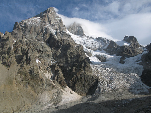
Eine liebenswürdige Ausnahme im Nomenklaturenkrieg ist eine Namensschenkung im Kaukasus. 1903 war die Bergsteigerin Cenzi von Ficker, Tochter einer Tiroler Gelehrtenfamilie, Mitglied einer erfolgreichen Expedition zum Südgipfel des Uschba (4737 Meter) im Kaukasus. Ihr schenkte - beeindruckt von der attraktiven Alpinistin - der Fürst der kaukasischen Region Swanetien, Tatarchan Dadeschkeliani, urkundlich beglaubigt den Berg Uschba. Cenzi von Ficker gelang zum Abschluss der Expedition noch die Erstbesteigung eines bis dahin namenlosen 3860 Meter hohen Gipfels, der seither als "Tsentsi Tau" im Register des Alpine Club of London vermerkt ist.
photo by Natia Zhorzheta, Ushba in Svaneti
Saturday, August 09, 2008
OPEN LETTER: 08-08-08
Seit ein paar Jahren bin ich mit dem Kaukasus verbunden. Angefangen hat es in meiner Jugend. Ich lebte in Ostdeutschland, weltweit bekannt geworden durch den Fall der Mauer. Damals träumte ich beim Lesen und wenn ich an das alpine Bergsteigen fern der Heimat dachte, von der Hohen Tatra, dann vom Kaukasus, dann dachte ich an den Pamir oder an das Altai-Gebirge. Der Everest lag für mich weit weg im Westen. Ich konnte und durfte nicht von dem Höchsten träumen. Ich wollte trotzdem auf einem eisigen und schönen Gipfel stehen und die klare Luft genießen. Beim Abstieg sollte ruhig der Wind an mir zerren, aber ich wollte den Gipfelsieg nach Hause bringen. Es sollte nur eine Geschichte sein, die ich gern weiter erzählen würde.
Älter geworden, nach dem Fall der Mauer in Ostdeutschland, wurde der "Fall der kruden Mauer-Architektur" ein Freiheits-Symbol in Retrospektiven - vor allem im Fernsehen. Seit dem gibt es für mich den klaren Ausblick oder geruhsamen Rückblick nicht mehr. Alle sprangen schon damals nur in den Staub. Die Mauer in Berlin wurde nicht wirklich gestürmt, denn die Leute saßen plötzlich einfach auf ihr. Sie hatten sie mit Hilfe von Räuberleitern erklommen und johlten schlecht gekleidet in die Kameras. Keiner hatte etwas dagegen. Es war unerfindlich. Erst dann bockten sie über und warfen sich in die offenen Arme des Westens zu ebener Erde und erwarteten das Paradies auf Erden. Sie waren nicht wirklich willkommen! Sie hatten ja auch nur ein paar Scheine in der Hand!
Es war nur eine Himmelsrichtung, der sie sich zuwendeten, wie es sich im Laufe der Zeit, andere sprachen damals vom Ende der Geschichte, herausstellte. Mittlerweile werden anderenorts aber wieder Mauern errichtet! Im Osten: Wir wollen es nicht sehen, denn wir leben im Westen! Und die mexikanische Grenzmauer ist hier kaum ein Begriff! Zu weit westlich von hier ... Was die Technik uns bringt, haben wir noch nicht wirklich erfasst. Jedenfalls verschwinden mehr und mehr die Himmelsrichtungen und auch unser Horizont. Wir wollen zum Mars fliegen, warum, dass weiß der liebe Teufel. Unsere Realität wird virtuell.
Die Chinesen haben es mit ihrer Mauer dagegen vor beinah einer Ewigkeit zum Weltwunder gebracht, was aber niemanden mehr wirklich interessiert! Noch ist sie nicht vergessen, was wohl daran liegt, dass sie unverstellbar weitläufig ist, man Eintritt bezahlt und zum Postkartenfetisch herhalten muss. Für uns liegt dieses gigantische Bauwerk aber nur im Osten! China gilt als ein Wunderland, dass uns irgendwie keine Freude bringen will. Asien fördert mit ihren vielen Menschen unsere Komplexe zu Tage! Es ist eben nicht mehr exotisch für uns! Es ist riesig. Irgendwo wächst etwas über uns hinaus. Wir kennen das Gewächs nur nicht, dass über unsere Köpfe hinaus treibt. Wir haben Angst vor der Wucherung.
Vor ein paar Stunden wurde dann in China mit einer Massenparade in einem gigantischen Stadium, gebaut von einem der zehn besten Architekten der Welt, die zeitgenössischen Olympischen Spiele eröffnet und Erinnerungen geweckt. Im Schatten gigantischer Feuerwerke, vielleicht eines der zehn größten Spiele überhaupt, wurde dann beinahe zwangsläufig auf allen Kanälen zeitgleich mit kleinen technischen Videokameras ein kleiner heftiger Krieg in Südossetien dokumentiert, den man noch, in zurückhaltender Weise, als einen eingefrorenen Konflikt bezeichnen wollte, der am Rande eines gewaltsamen Ausbruchs steht.
Klar ist mittlerweile, dass es Tote gab, wobei die Zahl derer, die ihr Leben ließen, medial vage veröffentlicht oder gar ungenannt blieb. Flugzeuge sind abgeschossen wurden, Panzer rollen, Gewehre schießen, Männer werfen sich in den Staub, Kinder werden evakuiert, Frauen sitzen in dunklen Kellern und Politiker geifern wie alte Weiber, wenn man ihnen Glauben schenken würde, und die Waffen selbst - die kennen wir nicht. Aber das kennen wir von der ohnmächtigen Berichterstattung des letzten Balkankrieges und auch aus dem Irak. Im schwarzen Afrika streckten lange Messer zahllose Nachbarn nieder, was auch unsere Vorstellungen übertraf, denn scharfe Klingen sind uns zwar wohl vertraut, doch das Abschneiden ist uns unheimlich. Schon Joseph Conrad berichtete von einzelnen Verwandlungen unserer Spezies ein paar Jahrzehnte zuvor in seinen Stories. Ein Serbe war in jüngster Zeit erst Arzt, dann Therapeut, dann Dichter, dann Redner und Verhetzer, dann Oberoffizier, Massenmörder und dann ein heiliger Wünschelrutengänger. Mit Mimikry hat das sicher nichts zu tun!
Der Überfall im Kaukasus während der Olympic Games geschah in einem unbekannten Randgebiet, wo Menschen leben, die klein, arm, eingezwängt, vielsprachig, uralt, anders, vor Kraft strotzend, selbstbewußt, stolz, ungestüm und orientierungslos in unserer großen weiten Welt sind. Es ist egal wer angefangen hat, denn das ist eine Kinderfrage, die dem Problem aus dem Weg gehen will! Die Menschen dort rieben sich auf in einem steinernen Meer, zwischen Boliden, in der Umgebung von Halbwüsten, inmitten unterschiedlicher Religionen, eingezwängt von Bergmassiven und Imperien und in ihrer Unkenntnis von der großen wirklichen Welt, obwohl sie normalerweise mit dem vielsprachigen Vielvölkergemisch urtümlich immer ganz gut zurecht kamen.
Dagegen träumten Sie oft in ihrem üppigen und kurzen Leben von dem Kind, der Liebe, der Leidenschaft, der Wollust, der Großzügigkeit, den Tod und der Unsterblichkeit. Sie liebten und kämpften für ihre eigene kleine Ewigkeit und das ihrer weit verzweigten Verwandten. Und trotzig nehmen sie deswegen alles zum Anlass, dem Übermaß und der Übermacht zu trotzen, die dem entgegen stehen: Russland, das im Norden ein enormes vernichtendes Potential haben kann - auch für ihr eigenes Volk; Europa, das sich immer noch in einer intelligenten Zurückhaltung und Vornehmheit übt, wenn es gleichzeitig alte Werte und moderne Interessen auf einmal bekunden will; das Heiland Amerika, dass wie üblicherweise wirkungsvoll und abschreckend einschreiten soll. Gegen diese haben die kleinlauten Helden der Berge nun ihr halsbrecherisches und ungerechtes Abenteuer in Angriff genommen - wie Halbstarke, die ihren Vätern etwas beweisen wollen, von denen sie nicht wirklich geliebt wurden, weil diese lieber in dunklen Spelunken für einen Vorteil oder gegen ihre gekränkte Seele zocken, statt mit den Halbwüchsigen eine beschwerliche Wanderung durch Täler auf die lichten Höhen zu unternehmen, dorthin wo Luft für alle da ist – und nicht noch höher hinauf in die kopfschmerzenden Todeszonen, wo man nur mit Hightech und Atemmasken zurecht kommt, und irgendwann trotzdem erstickt, verhungert, verdurstet, erfriert und einsam bleibt - mit der armseligen Zocke auf Tasche.
Ralph Hälbig
Älter geworden, nach dem Fall der Mauer in Ostdeutschland, wurde der "Fall der kruden Mauer-Architektur" ein Freiheits-Symbol in Retrospektiven - vor allem im Fernsehen. Seit dem gibt es für mich den klaren Ausblick oder geruhsamen Rückblick nicht mehr. Alle sprangen schon damals nur in den Staub. Die Mauer in Berlin wurde nicht wirklich gestürmt, denn die Leute saßen plötzlich einfach auf ihr. Sie hatten sie mit Hilfe von Räuberleitern erklommen und johlten schlecht gekleidet in die Kameras. Keiner hatte etwas dagegen. Es war unerfindlich. Erst dann bockten sie über und warfen sich in die offenen Arme des Westens zu ebener Erde und erwarteten das Paradies auf Erden. Sie waren nicht wirklich willkommen! Sie hatten ja auch nur ein paar Scheine in der Hand!
Es war nur eine Himmelsrichtung, der sie sich zuwendeten, wie es sich im Laufe der Zeit, andere sprachen damals vom Ende der Geschichte, herausstellte. Mittlerweile werden anderenorts aber wieder Mauern errichtet! Im Osten: Wir wollen es nicht sehen, denn wir leben im Westen! Und die mexikanische Grenzmauer ist hier kaum ein Begriff! Zu weit westlich von hier ... Was die Technik uns bringt, haben wir noch nicht wirklich erfasst. Jedenfalls verschwinden mehr und mehr die Himmelsrichtungen und auch unser Horizont. Wir wollen zum Mars fliegen, warum, dass weiß der liebe Teufel. Unsere Realität wird virtuell.
Die Chinesen haben es mit ihrer Mauer dagegen vor beinah einer Ewigkeit zum Weltwunder gebracht, was aber niemanden mehr wirklich interessiert! Noch ist sie nicht vergessen, was wohl daran liegt, dass sie unverstellbar weitläufig ist, man Eintritt bezahlt und zum Postkartenfetisch herhalten muss. Für uns liegt dieses gigantische Bauwerk aber nur im Osten! China gilt als ein Wunderland, dass uns irgendwie keine Freude bringen will. Asien fördert mit ihren vielen Menschen unsere Komplexe zu Tage! Es ist eben nicht mehr exotisch für uns! Es ist riesig. Irgendwo wächst etwas über uns hinaus. Wir kennen das Gewächs nur nicht, dass über unsere Köpfe hinaus treibt. Wir haben Angst vor der Wucherung.
Vor ein paar Stunden wurde dann in China mit einer Massenparade in einem gigantischen Stadium, gebaut von einem der zehn besten Architekten der Welt, die zeitgenössischen Olympischen Spiele eröffnet und Erinnerungen geweckt. Im Schatten gigantischer Feuerwerke, vielleicht eines der zehn größten Spiele überhaupt, wurde dann beinahe zwangsläufig auf allen Kanälen zeitgleich mit kleinen technischen Videokameras ein kleiner heftiger Krieg in Südossetien dokumentiert, den man noch, in zurückhaltender Weise, als einen eingefrorenen Konflikt bezeichnen wollte, der am Rande eines gewaltsamen Ausbruchs steht.
Klar ist mittlerweile, dass es Tote gab, wobei die Zahl derer, die ihr Leben ließen, medial vage veröffentlicht oder gar ungenannt blieb. Flugzeuge sind abgeschossen wurden, Panzer rollen, Gewehre schießen, Männer werfen sich in den Staub, Kinder werden evakuiert, Frauen sitzen in dunklen Kellern und Politiker geifern wie alte Weiber, wenn man ihnen Glauben schenken würde, und die Waffen selbst - die kennen wir nicht. Aber das kennen wir von der ohnmächtigen Berichterstattung des letzten Balkankrieges und auch aus dem Irak. Im schwarzen Afrika streckten lange Messer zahllose Nachbarn nieder, was auch unsere Vorstellungen übertraf, denn scharfe Klingen sind uns zwar wohl vertraut, doch das Abschneiden ist uns unheimlich. Schon Joseph Conrad berichtete von einzelnen Verwandlungen unserer Spezies ein paar Jahrzehnte zuvor in seinen Stories. Ein Serbe war in jüngster Zeit erst Arzt, dann Therapeut, dann Dichter, dann Redner und Verhetzer, dann Oberoffizier, Massenmörder und dann ein heiliger Wünschelrutengänger. Mit Mimikry hat das sicher nichts zu tun!
Der Überfall im Kaukasus während der Olympic Games geschah in einem unbekannten Randgebiet, wo Menschen leben, die klein, arm, eingezwängt, vielsprachig, uralt, anders, vor Kraft strotzend, selbstbewußt, stolz, ungestüm und orientierungslos in unserer großen weiten Welt sind. Es ist egal wer angefangen hat, denn das ist eine Kinderfrage, die dem Problem aus dem Weg gehen will! Die Menschen dort rieben sich auf in einem steinernen Meer, zwischen Boliden, in der Umgebung von Halbwüsten, inmitten unterschiedlicher Religionen, eingezwängt von Bergmassiven und Imperien und in ihrer Unkenntnis von der großen wirklichen Welt, obwohl sie normalerweise mit dem vielsprachigen Vielvölkergemisch urtümlich immer ganz gut zurecht kamen.
Dagegen träumten Sie oft in ihrem üppigen und kurzen Leben von dem Kind, der Liebe, der Leidenschaft, der Wollust, der Großzügigkeit, den Tod und der Unsterblichkeit. Sie liebten und kämpften für ihre eigene kleine Ewigkeit und das ihrer weit verzweigten Verwandten. Und trotzig nehmen sie deswegen alles zum Anlass, dem Übermaß und der Übermacht zu trotzen, die dem entgegen stehen: Russland, das im Norden ein enormes vernichtendes Potential haben kann - auch für ihr eigenes Volk; Europa, das sich immer noch in einer intelligenten Zurückhaltung und Vornehmheit übt, wenn es gleichzeitig alte Werte und moderne Interessen auf einmal bekunden will; das Heiland Amerika, dass wie üblicherweise wirkungsvoll und abschreckend einschreiten soll. Gegen diese haben die kleinlauten Helden der Berge nun ihr halsbrecherisches und ungerechtes Abenteuer in Angriff genommen - wie Halbstarke, die ihren Vätern etwas beweisen wollen, von denen sie nicht wirklich geliebt wurden, weil diese lieber in dunklen Spelunken für einen Vorteil oder gegen ihre gekränkte Seele zocken, statt mit den Halbwüchsigen eine beschwerliche Wanderung durch Täler auf die lichten Höhen zu unternehmen, dorthin wo Luft für alle da ist – und nicht noch höher hinauf in die kopfschmerzenden Todeszonen, wo man nur mit Hightech und Atemmasken zurecht kommt, und irgendwann trotzdem erstickt, verhungert, verdurstet, erfriert und einsam bleibt - mit der armseligen Zocke auf Tasche.
Ralph Hälbig
Wednesday, April 30, 2008
PHOTOGRAPHY: The Eagle in Tusheti
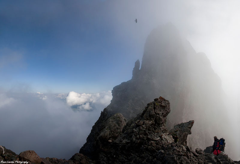 Chaukhi, Stefancminda district, dusheti region, Georgia
Photo: 29. April 2008 von The Alpinist: Roma Lomidze
Monday, July 16, 2007
PHOTOGRAPHY: Mestia In Svaneti

Mestia (Georgian: მესტია) is a highland townlet in northwest Georgia, at an elevation of 1.500 meters in the Caucasus Mountains.
According to the current administrative subdivision of Georgia, Mestia is located in the Samegrelo-Zemo Svaneti region (mkhare), some 128 km northeast of the regional capital of Zugdidi. Mestia and the adjoining 132 villages form Mestia District (raioni). Its area is 3,044 km²; population – 14,248 (2,600 in the town itself; 2002 Georgia census). The population is mostly Svans, a cultural subgroup of the Georgians.
Historically and ethnographically, Mestia has always been regarded a chief community of Zemo, or Upper Svaneti province. It was formerly known as Seti (სეთი). Despite its small size, the townlet was an important centre of Georgian culture for centuries and contains a number of medieval monuments - churches and forts - included in a list of UNESCO World Heritage Sites. In 1968, it was granted a status of a townlet (Georgian: daba).The townlet is dominated by stone defensive towers of a type seen throughout Svaneti ("Svan towers").
Unique icons and manuscripts are kept in Mestia Historical-Ethnographic Museum. Mestia is also a center of mountaineer tourism and alpinism.
Monday, January 15, 2007
SCIENCE: CENTRE FOR ARCHAEOLOGICAL RESEARCH
CENTRE FOR ARCHAEOLOGICAL RESEARCH
Georgian Academy of Sciences, 14 Uznadze St., Tbilisi 380002
Republic of Georgia
CenterArchTrans
Caucasus Journal of Anthropological Archaeology
Ushba Svanetia Watchtowers Mountains Maps Svans Art Alpine trek Creator
Ushba Svanetia Watchtowers Mountains Maps Svans Art Alpine trek Creator
To my dear friends and colleagues:Sakartvelo (Georgia) is an ancient land teeming with complex, often sparring cultures. Svaneti, the most beautiful and picturesque alpine region, is situated on the southern slope of the Main Caucasus Range, its virgin waters cascading steeply downward from stunning mountains such as the twin peaked Ushba, through glaciated highland valleys to form the rivers Enguri, Kodori and Tskhenistsqali.
This timeless, unique land has preserved until the present day the unrepeatable splendour of nature's first creations, magnified in stark relief through its rugged landscapes, painting a rare, exotic picture of the harmonic convergence of cultural and geo-historical legacies, resplendent in its many-faceted flora and fauna. Ancient turrets rise to vie with lofty crags. Svaneti artistic creations of gold and bronze, copper and earthen wares, knitting and handicrafts give testament to its native ingenuity, encoding its myths of creation in folklore handed down from time immemorial, echoed in the plaintive strains of Svan music.
In ancient times the Greco-Roman civilized world evinced great interest in Svaneti (witness the myths of Jason and the Golden Fleece [Colchis was the home of Medea and a special center of sorcery. Strabo explains the legend of the Golden Fleece for which Jason sought by saying that the natives strained the gold from their mountain streams through fleecy skins.] and Prometheus and the Caucasus [Aeschyllus and Apollodoros described the location, appearance and dimensions of the double-vaulted mountain where Prometheus was bound, evoking highly symbolic images reminiscent of Svanetian mythology associated with Mount Ushba.]).
In the 19th century Svaneti became the object of inexhaustible interest for writers, artists, and travellers from around the world. Hence Svaneti has acquired various non-de-plumes such as "The Land of a Thousand Towers and Glaciers", "The Treasury of National Culture", "A Living Scientific Laboratory" and other noble designations.
This timeless, unique land has preserved until the present day the unrepeatable splendour of nature's first creations, magnified in stark relief through its rugged landscapes, painting a rare, exotic picture of the harmonic convergence of cultural and geo-historical legacies, resplendent in its many-faceted flora and fauna. Ancient turrets rise to vie with lofty crags. Svaneti artistic creations of gold and bronze, copper and earthen wares, knitting and handicrafts give testament to its native ingenuity, encoding its myths of creation in folklore handed down from time immemorial, echoed in the plaintive strains of Svan music.
In ancient times the Greco-Roman civilized world evinced great interest in Svaneti (witness the myths of Jason and the Golden Fleece [Colchis was the home of Medea and a special center of sorcery. Strabo explains the legend of the Golden Fleece for which Jason sought by saying that the natives strained the gold from their mountain streams through fleecy skins.] and Prometheus and the Caucasus [Aeschyllus and Apollodoros described the location, appearance and dimensions of the double-vaulted mountain where Prometheus was bound, evoking highly symbolic images reminiscent of Svanetian mythology associated with Mount Ushba.]).
In the 19th century Svaneti became the object of inexhaustible interest for writers, artists, and travellers from around the world. Hence Svaneti has acquired various non-de-plumes such as "The Land of a Thousand Towers and Glaciers", "The Treasury of National Culture", "A Living Scientific Laboratory" and other noble designations.
The study of the cultural legacy of Svaneti through the excavation, reconstruction and interpretation of its physical remains is led by a special expedition of the Center for Archaeological Research of the Academy of Sciences of Georgia, which has already brought to light over 200 significant artifacts from the Neolithic, Bronze, Greco-Roman and Middle Ages; mining and metallurgical complexes; structures erected for cult worship, defense fortifications, burial sites and living settlements.
In the course of these excavations there have been discovered several thousand examples of artistic handicraft work, the product of various epochs, which clearly show the key roles which the natural environment of the mountains, its flora and fauna, and domesticated and wild animals played in the religious cult of the Svanetians. These handicraft wares at the same time reveal vital information regarding the exploitation of natural resources by the local populace, the development of ancient metallurgical engineering processes, artistic tastes, and trade capabilities in the region. These materials are routinely processed and analyzed at the on-site storage center for the expedition in Svaneti (Mestia Settlement).
At the present time, archaeological research in Svaneti (and for that matter, in the whole of Georgia) has been suspended in connection with the continuing economic financial crisis. The expedition simply does not possess adequate governmental, corporate or institutional funding to cover expenditures and necessities in order to carry out basic field research on a material-technical basis.
It sorely needs a contemporary computer configuration (integrating server-monitors-high res. scanner-printers-copiers-faxes-modems-digital still & video cameras) with compatible architectural CAD software for the purpose of amplifying archaeological reconstructions, generating graphics, enhancing photographic procedures and reconfiguring designated exhibits (artifacts), whatever the size or the scope of the finds.
The Svaneti Expedition (if reconstituted) additionally needs mountain-climbing equipment and clothes, sleeping bags and tents; electrical generators and an array of western-standard lighting equipment (cables, fixtures, replacement bulbs) for the proper illumination of the old mine workings (galleries); materials for the rigging and re-shoring of the mine workings infrastructures; horses and equestrian supplies, an all-terrain jeep for reconaissance; a truck with independent suspension to ensure the safe transfer of archaeological remains; and for the pick-up and delivery of fuel a small tanking trailer is also required. The purchase of relevant equipment, such as basic spellunking gear, handheld satellite telemetry devices for zeroing in on (and re-locating old) finds and the cartographic tools necessary to chart them, would be a step in the right direction. Finally, the Archaeological Institute seeks to acquire instrumentation to facilitate radio-carbon dating procedures and X-ray analysis of material finds.
The Archaeological Expedition of Svaneti has presently at its command for the reception of foreign colleagues and invited guests, the following: an archaeological base, basic transportation, lodging (under communal living conditions), flats in Tbilisi and Svaneti, and interpreters.
My dear friends: Georgia has recently taken its first steps towards eventual integration into the European Economic and Political Union. It has already established promising scientific, cultural and economic contacts with the United States of America. The Expedition Center of Svaneti for Archaeological Research is looking for serious sponsors to help underwrite the expense of mounting future expeditions. We hope to collaborate together with leading archaeologists and anthropologists in the sphere of researching the physical and spiritual culture of Svaneti.
We also seek legal representation for contractual purposes and a university publisher for a proposed English language translation of my book Ancient Svanetia, which is available for your review (in Georgian) upon request. Please respond on a timely basis, indicating if your institution has an interest in participating in digs this summer, and/or assisting our Archaeological Center in Tbilisi and Museum in Mestia, which would like to create a travelling exhibition of Svanetian artifacts in the United States during the forthcoming year. Come to Sakartvelo and enjoy the wonders of exotic Svaneti.
At the present time, archaeological research in Svaneti (and for that matter, in the whole of Georgia) has been suspended in connection with the continuing economic financial crisis. The expedition simply does not possess adequate governmental, corporate or institutional funding to cover expenditures and necessities in order to carry out basic field research on a material-technical basis.
It sorely needs a contemporary computer configuration (integrating server-monitors-high res. scanner-printers-copiers-faxes-modems-digital still & video cameras) with compatible architectural CAD software for the purpose of amplifying archaeological reconstructions, generating graphics, enhancing photographic procedures and reconfiguring designated exhibits (artifacts), whatever the size or the scope of the finds.
The Svaneti Expedition (if reconstituted) additionally needs mountain-climbing equipment and clothes, sleeping bags and tents; electrical generators and an array of western-standard lighting equipment (cables, fixtures, replacement bulbs) for the proper illumination of the old mine workings (galleries); materials for the rigging and re-shoring of the mine workings infrastructures; horses and equestrian supplies, an all-terrain jeep for reconaissance; a truck with independent suspension to ensure the safe transfer of archaeological remains; and for the pick-up and delivery of fuel a small tanking trailer is also required. The purchase of relevant equipment, such as basic spellunking gear, handheld satellite telemetry devices for zeroing in on (and re-locating old) finds and the cartographic tools necessary to chart them, would be a step in the right direction. Finally, the Archaeological Institute seeks to acquire instrumentation to facilitate radio-carbon dating procedures and X-ray analysis of material finds.
The Archaeological Expedition of Svaneti has presently at its command for the reception of foreign colleagues and invited guests, the following: an archaeological base, basic transportation, lodging (under communal living conditions), flats in Tbilisi and Svaneti, and interpreters.
My dear friends: Georgia has recently taken its first steps towards eventual integration into the European Economic and Political Union. It has already established promising scientific, cultural and economic contacts with the United States of America. The Expedition Center of Svaneti for Archaeological Research is looking for serious sponsors to help underwrite the expense of mounting future expeditions. We hope to collaborate together with leading archaeologists and anthropologists in the sphere of researching the physical and spiritual culture of Svaneti.
We also seek legal representation for contractual purposes and a university publisher for a proposed English language translation of my book Ancient Svanetia, which is available for your review (in Georgian) upon request. Please respond on a timely basis, indicating if your institution has an interest in participating in digs this summer, and/or assisting our Archaeological Center in Tbilisi and Museum in Mestia, which would like to create a travelling exhibition of Svanetian artifacts in the United States during the forthcoming year. Come to Sakartvelo and enjoy the wonders of exotic Svaneti.
With the highest respect,
Shota Chartolani
Head of Expedition of Svaneti
Doctor of Historical Sciences
Professor
Center for Archaeological Research
Uznadze Street, No. 14
Tbilisi 380002, Georgia
FAX: 995-, 8832, 96-67-68

Wednesday, February 15, 2006
HISTORY: A Passion for Svaneti - Vittorio Sella travelled to Svaneti and Racha
 "[...] To Georgians, the Svanetian has always personified pride and persistence. Vittorio Sella, a famous Italian mountaineer and photographer of the 19th century, spent considerable time exploring the wonders of Svaneti. Photographs taken during his travels there reveal the people who have also been influenced by their natural environment. They are tall like their mountains and their eyes are as blue as the Svanetian sky. Vittorio Sella travelled to Svaneti and Racha three times and mounted 30 peaks. He compiled a valuable material on Georgia. His photographs were exhibited in London in 1890 and received the highest award by the Royal Geographic Society [...]
[more >>>]
Links:
* Vittorio Sella - Portraits Vittorio Sella ist wohl der grösste Bergfotograf, den es in der Geschichte desBergsteigens je gegeben hat.
* Vittorio Sella FOTOGRAFIE fotografie della sardegna - cagliari ... Biografie di fotografi, news, libri, recensioni e documenti bibliografici, Mostre,gallerie, fotografie della sardegna - cagliari - oristano - nuoro ...
* The Georgian Museum of Photography - In the centre of Vittorio Sella, 1889. Collections - V. Sella. SpyLOG. Copyright ©2004. The Georgian Association for the History of Photography in the ...
Subscribe to:
Posts (Atom)